Redbreast Maori wrasse
Cheilinus fasciatus
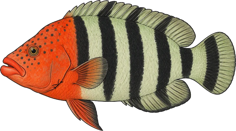
Illustration: Bloom by Day
Pale green-grey crossed by five or six broad black bars, with the whole head and chest flushed orange-red and finely black-spotted, and the thick lips the Maori wrasses all share. It follows rays and goatfish along the bottom waiting for something to be turned up, so a diver often meets it tagging along behind another animal.
how to recognise it
- a broad orange-red area over the chest and forward to the eye
- about five whitish bars down the side
- short orange lines radiating from the eye
- white tail with a black rear margin and a black bar that stops short of the lobes
don’t confuse with
- Tripletail Maori wrasse — the tripletail has no orange chest and its tail grows three lobes on a big male
- Humphead Maori wrasse — the humphead is enormous, with a forehead hump and thick lips — nothing else is a metre of wrasse
Field marks read from Fishes of Australia, 2026-10-13. Our wording, their facts. Max size 36 cm.
facts
- habitat
- reef
- size
- ~30 cm, to 36 cm
Max size from Fishes of Australia (36 cm); the typical size is Bluebird’s, not from a cited source
- records
- 2185 at 25 spot(s), none of
them in this region
Recorded at Osprey Reef (Coral Sea), Lizard Island — Cod Wall, Cod Hole (Ribbon Reefs GBR), Low Isles (Port Douglas), Port Douglas (Outer GBR), Green Island (Cairns), Fitzroy Island (Cairns), Frankland Islands (Cairns), Magnetic Island — Geoffrey Bay, SS Yongala Wreck, Marion Reef (Coral Sea), Hardy Reef (Whitsundays), Bait Reef (Whitsundays), Hayman Island — Blue Pearl Bay, Hook Island — Manta Ray Bay, Border Island (Whitsundays — East), Tongue Bay (Whitsunday — North), Cid Harbour (Whitsunday — West), North Horn (Coral Sea), Cairns Reef (Great Barrier), Heron Island (GBR), Erskine Island, Lady Musgrave Island, Vavau (Tonga), Flinders Reefs (Coral Sea). A count of occurrence records, not abundance. Records are where someone looked.
- deepest record
- 4 m
The deepest occurrence record near these spots. This is NOT the species depth range.
when it has been recorded
JFMAMJJASOND
A gap means no record in the sample, not absence.
the rule
QLD — Min: 25cm · Limit: 5
source
· verified 2026-10-10
no NSW rule listed — check before you dive
QLD s 23 — closed season 6 November 2026 to 10 November 2026 (20 windows listed)
as regulated coral reef fin fish = any species in Fisheries (General) Regulation 2019, sch 7 pt 2 (tables 1-9) — table 9 (wrasse)
where: coral reef fin fish waters — tidal waters within the boundary from the northern tip of Cape York along latitude 10º41' south ... to latitude 24º50' south, longitude 154º east ... along latitude 24º50' south to the mainland shore
Whether it applies where you dive depends on the spot — open that spot on the map and press “fish here”.
Fisheries Declaration 2019 · Reprint current from 25 September 2026 to date · read 2026-10-13
Rules checked 2026-10-13 against qld.gov.au
Rules change. Check before you dive.
Occurrence data: Atlas of Living Australia (ala.org.au), CC-BY 4.0.
Diver transect counts: Reef Life Survey (reeflifesurvey.com), CC-BY 4.0, supplied via ALA.
Target and protected species: Queensland tidal-water size and possession limits (qld.gov.au) and NSW saltwater bag and size limits plus threatened species lists (dpird.nsw.gov.au).
Habitat and size: Bluebird, approximate, from general knowledge. Not cited. FishBase is CC BY-NC and this app is commercial, so it is not used.
Description written for Bloom. RECORDS ARE WHERE SOMEONE LOOKED, NOT WHERE THE FISH ARE. A record count is a count of records near here and nothing else -- it is not abundance, and a species with few records is not rare. Absence of records is not absence of fish.
Diver transect counts: Reef Life Survey (reeflifesurvey.com), CC-BY 4.0, supplied via ALA.
Target and protected species: Queensland tidal-water size and possession limits (qld.gov.au) and NSW saltwater bag and size limits plus threatened species lists (dpird.nsw.gov.au).
Habitat and size: Bluebird, approximate, from general knowledge. Not cited. FishBase is CC BY-NC and this app is commercial, so it is not used.
Description written for Bloom. RECORDS ARE WHERE SOMEONE LOOKED, NOT WHERE THE FISH ARE. A record count is a count of records near here and nothing else -- it is not abundance, and a species with few records is not rare. Absence of records is not absence of fish.